This article was written by Anna Smyth, as part of the undergraduate module Introduction to Disaster Management at HCRI. Anna received the highest marks for this assignment and her work was commended for publication by her tutor, Dr Pedro Silva Rocha Lima. Thank you Anna!
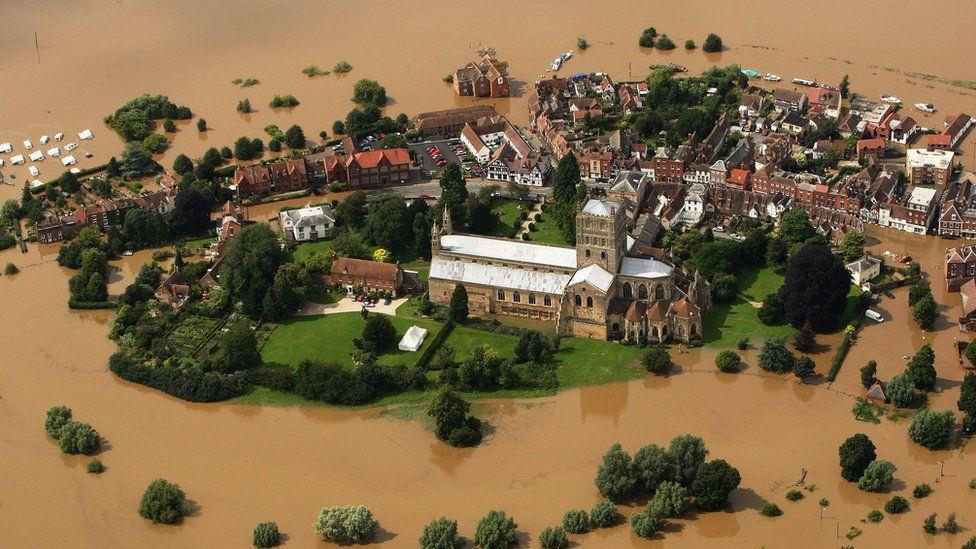
Figure 1: Tewkesbury 2007 floods
It is 9am on Friday the 20th of July 2007 in Tewkesbury, Gloucestershire, and the town has seen four months of rainfall in a matter of 14 hours. Within the hour, flash flooding begins, and the emergency services start to get calls. By 4pm, more than 100 roads in the county are underwater. Four hours later, the emergency services have received 1,800 calls. It’s now 9am the next day, and the rivers Severn and Avon have broken their banks, wreaking havoc on the Gloucestershire market town. Overnight, the water treatment plant is flooded and is forced to shut down, leaving 350,000 people without clean, running water for 18 days. As Sunday afternoon approaches, electricity is shut off for 48,000 people for 19 hours, and as evacuations begin, the locals of Tewkesbury start to realise the extent of the danger they are in. As a result of the late July floods, 3,966 houses were flooded, 825 households were forced to evacuate their homes, 20 schools were damaged, 500 businesses were flooded, and three people lost their lives. The event is described as “the biggest civil emergency since WWII” and warranted two visits from Prime Minister Gordon Brown in only three days. In such a developed country, we can’t help but wonder whether all this could have been avoided? Unfortunately, the short answer is yes. Disasters like these are a product of processes that precede them by decades, if not centuries.
A natural disaster is defined by Britannica as “any calamitous occurrence” caused by natural phenomena that leads to “loss of human life or destruction of the natural environment, private property, or public infrastructure.” Now, this event is most certainly a disaster, but the real question lies in whether the event can be considered ‘natural’. Can we truly accept that the causes of these floods were beyond human control? A lack of responsibility can only prevent proper assessment and evaluation of disasters; we must recognise where humans are responsible so that we can develop our response as well as our preparation. First and foremost, it is important to understand Tewkesbury geographically before jumping to conclusions. The town lies on the convergence of two major rivers, the Severn and Avon; the Severn being the largest river in Britain (Figure 2).
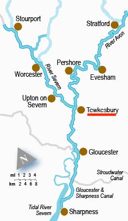
Figure 2: Map to show convergence of rivers Severn and Avon
Additionally, while Tewkesbury is low lying, with elevation levels below 10 metres at some points (Figure 3), it is surrounded by a significant number of hills and mountains, with elevations upwards of 220 metres (Figure 3), which inevitably leads to increased surface run off.
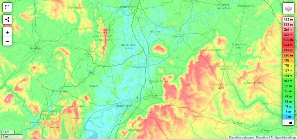
Figure 3: Elevation map of Tewkesbury and the surrounding area
Additionally, the urban development of the area, including the M5 and M50 which enclose Tewkesbury, contribute to the lack of permeable surfaces, which is directly linked to increased risk of flash flooding. Also contributing to surface run off are soil saturation levels, due to monoculture and livestock trampling of the surrounding farmland; water is unable to percolate into groundwater flow. Additionally, the European Environmental Agency has “no record of licensed groundwater abstractors within a 1km radius of the site”, meaning soil will be more susceptible to becoming saturated in heavy rainfall. “The water has to go somewhere!” as Dawn Ray, a Tewkesbury resident remarked in response to the influx of urban development in the area. The Gloucester City Council website features a mapping tool that highlights areas of risk that are in flood plains. In all four categories of flood risk, almost all of Tewkesbury is engulfed in colour (Figure 4), highlighting the extent of the risk.
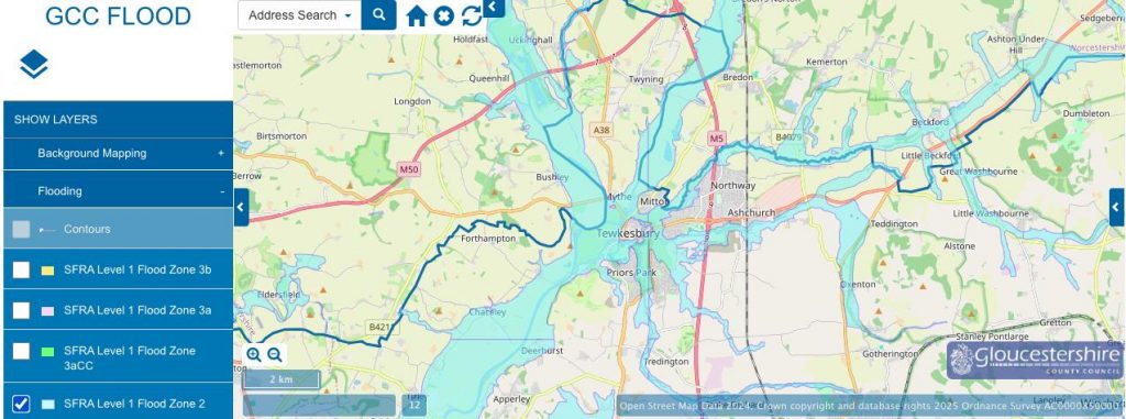
Figure 4: A map to show flood plain zoning of Tewkesbury
In light of this knowledge, town and county councils should have been more stringent on topics such as building regulations and drainage systems. We can assert that the extensive flooding of 2007 was partly down to human negligence and inability to respond appropriately to risk assessments.
There are a multitude of ways that flood risk can be mitigated with a specific focus to the river itself. Methods include dredging, to remove excess material at the bed of the river so that the channel can hold more water, and channel straightening, which allows the water to travel out of the area quicker, with less resistance. These methods are very effective for reducing flood risk considerably in a built-up area. However, both methods speed up the flow rate for areas further down the river course, increasing the flood risks for those downstream. Upton-upon-Severn (Figure 5) is a small village a ten-minute drive north of Tewkesbury that also experiences extensive flooding, thus are compelled to use both dredging and channel straightening as methods of river management.
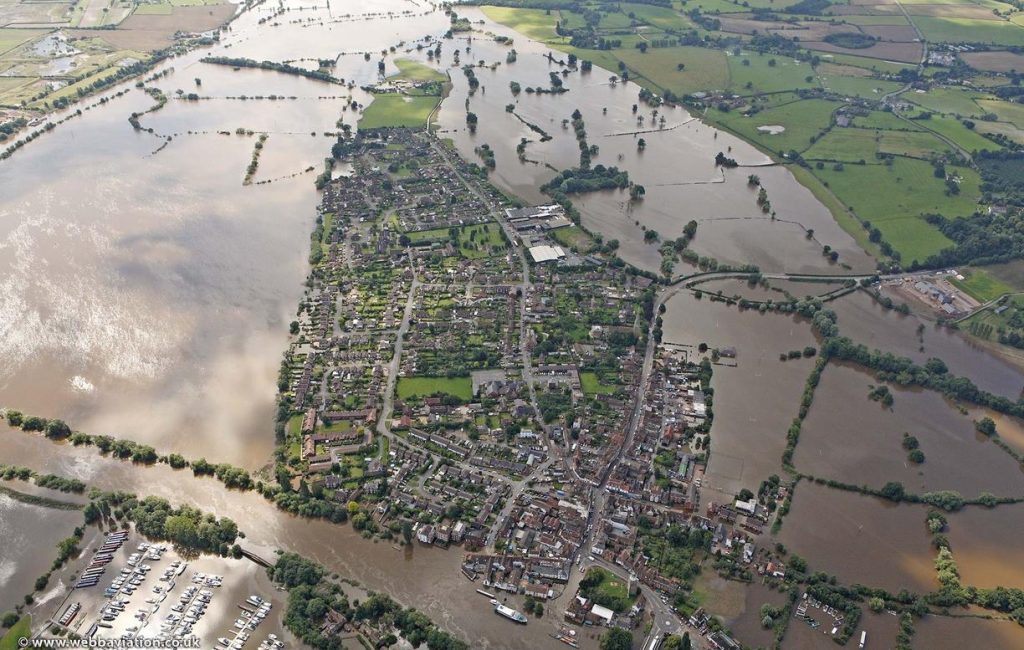
Figure 5: A photograph to show Upton-upon-Severn flooding in 2007
It is important to consider that the River Severn has the highest rate of discharge in Great Britain, with 21 tributaries contributing to the flow of the river, and a water speed of 25mph during peak discharge. With this in mind, we can imagine the increased risk that Tewkesbury is in due to the flood defences of many towns upstream.
A disaster can almost fully be defined by the response of authorities and local communities that mitigates the effects and impacts of the natural hazard. £1.84million was donated to the Gloucester Flood Relief Fund by businesses, organisations and families; the fund reached £400,000 within days after an undisclosed amount was donated by the then Prince Charles. Additionally, more than 250 military personnel were sent to support the efforts, with helicopters and inflatable boats carrying out rescues. Vernon Smith, a civil engineer and town councillor whose home was extensively damaged in the floods, noted that in meetings after the event, there were discoveries that “there had been no maintenance done for 20 to 30 years”, regarding the upkeep of flood defences in the town. This recount supports the idea that the flooding and subsequent damages were caused by anthropogenic processes, not natural ones.
In sum, the 2007 Tewkesbury floods were caused by anthropogenic activity, and thus cannot be considered ‘natural’. According the Environmental Agency in 2009, one in six homes in England and Wales was “in danger of flooding from rivers or the sea”. Considering the current threats of climate change, leading to increased frequency and intensity of storm events, we must not ignore the weaknesses in our management that were exposed by this so-called ‘natural’ disaster over 17 years ago.
—
References:
BBC (2025). Gloucestershire | Prime minister visits flood teams. [online] Available at: http://news.bbc.co.uk/1/hi/england/gloucestershire/6916010.stm.
Dhonau , M. (2008). Building on the floodplain is misguided (a proof of evidence). [online] Available at: https://flooding.london/jrp/Report%202008.pdf.
Environmental Agency. (2021). Floods and dredging: explaining the Environment Agency’s approach – Creating a better place. [online] Available at: https://environmentagency.blog.gov.uk/2021/12/23/floods-and-dredging/.
Environmental Statement: Ground Conditions. (2021). Available at: https://tewkesbury.gov.uk/wp-content/uploads/2022/Planning/Planning%20appeal%20core%20documents/Fiddington/A1%20-%20A23/A1.19%20-%20N%20-%20012.%20GROUND%20CONDITIONS.pdf.
Environmental Statement: Soils And Agriculture. (2021). Available at: https://tewkesbury.gov.uk/wp-content/uploads/2022/Planning/Planning%20appeal%20core%20documents/Fiddington/A1%20-%20A23/A1.19%20-%20P%20-%20014.%20SOILS%20AND%20AGRICULTURE.pdf.
European Commission (2023). How Climate Change Is Disrupting Rainfall Patterns and Putting Our Health at Risk. [online] climate.ec.europa.eu. Available at: https://climate.ec.europa.eu/news-your-voice/news/how-climate-change-disrupting-rainfall-patterns-and-putting-our-health-risk-2023-08-03_en.
Freecountrymaps.com. (2025). Upton-upon-Severn Map Great Britain Latitude & Longitude: Free England Maps. [online] Available at: https://www.freecountrymaps.com/map/towns/great_britain/266033028/.
Gloucestershire.gov.uk. (2025). Flood zones in Gloucestershire | Gloucestershire County Council. [online] Available at: https://www.gloucestershire.gov.uk/planning-and-environment/flood-risk-management/flooding-information/information-for-developers/flood-zones-in-gloucestershire/.
https://www.facebook.com/CanalJunction (2024). River Severn & River Avon Map and Holiday Cruising Guide. [online] Canal Junction Maps. Available at: https://www.canaljunction.com/canal/severn_avon.htm.
Internet Geography. (2023). Hard Engineering River Management. [online] Available at: https://www.internetgeography.net/topics/hard-engineering-river-management/.
Internet Geography. (2025). Tewkesbury Floods 2007 Case Study. [online] Available at: https://www.internetgeography.net/topics/tewkesbury-floods-2007-case-study/.
Jenkins and Falconer (2017). The Floods 10 years on. [online] Gloucestershire Live. Available at: https://thefloods.gloucestershirelive.co.uk/.
John, J. (2021). Monoculture Could Make Climate Change Even Scarier. [online] Food Tank. Available at: https://foodtank.com/news/2021/02/monoculture-could-worsen-vulnerability-to-climate-change/.
Society, T.R.G. (2025). Discovering Britain – Tewkesbury Floods. [online] www.discoveringbritain.org. Available at: https://www.discoveringbritain.org/activities/south-west-england/aerial/britain-from-the-air-tewkesbury-floods.html.
topographic-map.com (2025). Tewkesbury topographic map, elevation, terrain. [online] Topographic maps. Available at: https://en-gb.topographic-map.com/map-58dn/Tewkesbury/?center=52.00886%2C-2.16618&zoom=12&popup=52.05345%2C-2.06937.
Veerappan, R. (2020). Flood Influencing Factors. [online] Research Gate. Available at: https://www.researchgate.net/figure/Flood-influencing-factors-a-slope-b-elevation-c-curvature-d-TWI-e-SPI-f_fig2_339681012.
Webbaviation.co.uk. (2025). Upton-upon-Severn during the great floods of 2007 from the air. [online] Available at: https://www.webbaviation.co.uk/aerial/picture.php?/23560.
Wikipedia Contributors (2019). River Severn. [online] Wikipedia. Available at: https://en.wikipedia.org/wiki/River_Severn.
Wikipedia Contributors (2024). A40 road. [online] Wikipedia. Available at: https://en.wikipedia.org/wiki/A40_road.
Wikipedia Contributors (2020). 2007 United Kingdom floods. [online] Available at: https://en.wikipedia.org/wiki/2007_United_Kingdom_floods.
Wright, L. (2017). The wettest summer on record. BBC News. [online] 22 Jul. Available at: https://www.bbc.co.uk/news/uk-england-40548635.
European Environment Agency (2025). Groundwater abstraction — European Environment Agency. [online] Available at: https://www.eea.europa.eu/archived/archived-content-water-topic/wise-help-centre/glossary-definitions/groundwater-abstraction.