How I identified and mapped 1000+ trees in the Fallowfield Campus
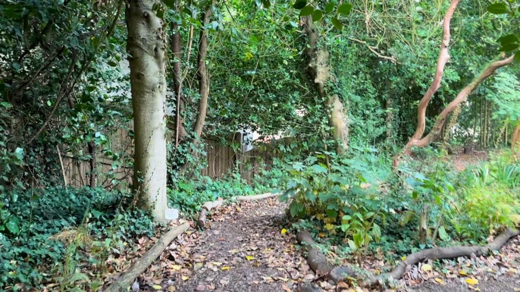
If you look closely at a satellite image of the Fallowfield Campus, you may spot a small rectangular plot, sandwiched between Richmond Park and Uttley House. This is the Firs Botanical Grounds, home to the University’s environmental research station, greenhouse laboratories, living plant collection and air quality research laboratory.
Unless you are a student, staff member, or a resident of the Fallowfield Campus, you may well complete your university career without knowing the existence of this place. I, however, found myself well-acquainted with the site through an eight-week Student Experience Internship (SEI), and I am excited to share the insights I have gained.
About my internship
The main goal of my SEI, “Surveying the Green Spaces of Fallowfield,” was to complete a Phase 1 Habitat Survey. For context, Phase 1 Habitat Surveys are a tool used by ecologists to assess the ecological value of a site by categorising areas into different habitats, often providing additional information on their biodiversity and condition for a specific purpose. In my case, I was laying the basic groundwork and providing recommendations for the University’s plan of developing a public Botanical Gardens in Fallowfield.
Considering the extensive process of surveying — from desk research to field work, mapping and report write-up — and the decent size of the campus (around 70 acres), this SEI was no easy feat. Fortunately for me, I had prior experience from my field course research skills module (RSM) — BIOL20872 Urban Biodiversity and Conservation which provided me with foundational surveying skills.
Day-to-day for the first week, I spent most of my time researching inside the mess room. This allowed me to learn about the history of the campus, study ordinance survey maps, and identify the green areas between residential buildings.
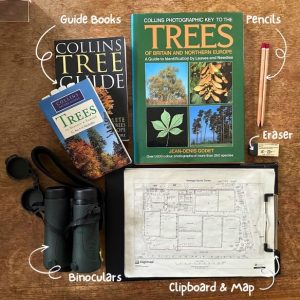
Photo of the basic tools I used for field work and species identification.
In Weeks 3 – 6, I carried out field work and created a Phase 1 Habitat Survey map of the site, a major output of the internship. Most days, while out on site I mapped templates by zooming into different parts of the campus, jotting down the species, landscape and condition of each area to help me decide on the most suitable habitat categorisation.
While it is possible to do the survey by hand (different colours and patterns for each habitat), I decided to do use a modern technique: Geographic Information System (GIS) software, ArcGIS Pro. I reviewed YouTube tutorials and conducted trial-and-error tests to figure out how to use it –I am still far from being an expert, but the experience was hugely rewarding. Not only was I able to create a high-quality digital map with metadata and additional features that are impossible to achieve with pen and paper, but I also gained invaluable practical skills that I can use to enhance my CV.
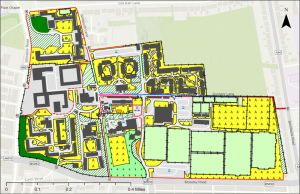
Phase 1 Habitat Survey Map of Fallowfield Campus. Created using ArcGIS Pro.
I used the last two weeks of my internship to write up the report and finalise my tree trail design — more on that in the next section. In addition to the subject specific tasks provided by the internship, being on the Firs Botanical Grounds also offered plenty of other wellbeing and social opportunities. There is the option to help around the Firs Botanical Grounds in different ways, including watering the plants and feeding the fish, which was a great chance to take a mental break from work. Not to mention, there were two other student interns working on the site at the same time, allowing us to collaborate and share ideas while making new friends.
Tree identification and tree trail design
My SEI was largely self-guided, supported by supervisor Professor Giles Johnson and overlooked by Oliver Hughes, Firs Botanical Grounds site manager.
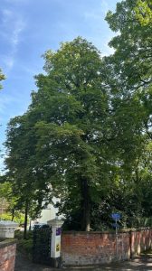
Photo of a horse chestnut tree (Aesculus hippocastanum) in Uttley House, showcasing its broad canopy. This is one of the trees of the tree trail.
In addition to the habitat survey, I was also tasked with creating a tree trail to add to the Firs Botanical Grounds web app developed by Giles. I was allowed a huge degree of creative freedom for this task, which was both exciting and slightly daunting at the same time!
With this project in mind, I identified and mapped each individual tree around the Fallowfield Campus while completing the habitat survey. This became a formidable challenge, and while I cannot confidently say that I accurately identified every tree or mapped them to the precise coordinate I gave it my best shot. With a combination of field guides, help from Oliver and the horticultural technician Osian, satellite images and mobile GPS tools I marked down a total of 1408 trees, evidenced by individual dots on my final Phase 1 Habitat Survey map.
As I was identifying trees and noting their locations, I was constantly brainstorming about the tree trail. Eventually, I had decided on the following:
- There would be ten trees of different species in the trail, with at least one in each ‘area’ or residential zone of the Fallowfield Campus to ensure the trail was spread across the site equally.
- The ten species of trees would be tied together by the theme of “Climate Change”, with information highlighting each of their links to the topic, including unique facts and features to tackle or resist climate change.
- These facts would be presented in the form of 1- or 2-minute YouTube videos, along with short written descriptions.
To achieve this ambitious goal, I recorded “stock clips” while on site that I could use for my tree trail videos and added voice-over narrations later. I was familiar with fast-paced video production through a prior experience at my Rootstock Plant SciComm Residential in 2024, and I was able to further enhance my skillset by becoming more acquainted with scriptwriting and the video-editing software CapCut. I even attended a video-editing training session hosted by the University’s Media Services which provided me with professional insights that I would never have gained through self-exploration alone.
A take-home message
Participating in this SEI was immensely rewarding—not only because of the valuable experiences and practical skills I can now showcase on my CV, but also because it offered a glimpse into what a career in ecology or environmental work might entail. It was one of the standout moments of my university journey, solidifying my passion for this field and guiding me toward a future career in it.
I strongly encourage penultimate-year students, including international students like myself, to explore SEIs as a meaningful way to make the most of the long three-month summer break. Plus, the flexibility in arranging the eight-week internship meant I still enjoyed a three-week vacation at home before the new academic year began!
Lastly, I encourage anyone to get involved with the Firs Botanical Grounds work, and to get out and enjoy the green spaces on Fallowfield Campus. Maybe you could use the Firs Botanical Grounds web app or the Fallowfield Tree Trail to learn more about the plants we share campus with!
Additional information
- The information in this blog aligns with the UN Sustainable Development Goals 11 (Sustainable Cities and Communities) and 15 (Life on Land).
- Links to Phase 1 Habitat Survey Map:
- Web Map (view only)
- Web Map (editable for UoM)
- ArcGIS Pro Project Package (available for download for local use — desktop application required)
- Links related to tree trail:
- YouTube Playlist (“Fallowfield Tree Trail”)
- Firs Botanical Grounds web app
0 Comments